Earltown’s First Murderer – Domhnall Caimbeul

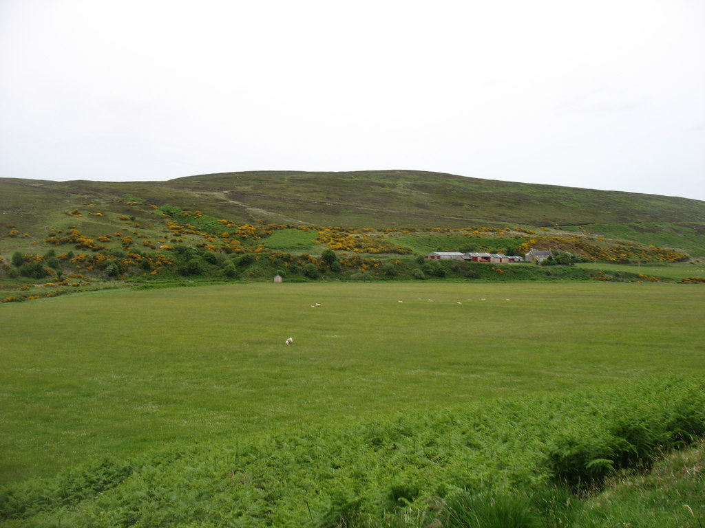
The scene above is from a view point on Campbell’s Hill, southeast of the village of Scotsburn.  It is a spring day in which the leaves are just beginning pop out. In the near distance is the tower on Bethel Presbyterian Church. A bit further in the view is a ridge adorned with farms in the community of Heathbell.  In the distance is the blue waters of the Northumberland Strait and, on the horizon, the eastern end of Prince Edward Island.  It is a peaceful spot that gladdens the soul.

It was not always that way.  In 1819, a few dozen feet from this viewpoint, the most horrendous murder in Pictou County, (at least up until 1877), was committed.

This farm was first settled by a Campbell family, probably around 18031.  They were from Rogart in Sutherland.  The next farm up the hill was also settled by a Campbell family2, most likely a sibling or near relation.  The names of the parents are presently unknown.  Their graves, whether in Scotsburn or Durham, are unmarked.  The mother died before 1819 after which the father took a second wife, also a Campbell, who was part of a Campbell clan on Scotch Hill.  Of the first marriage, we only know of one son – Donald – the principal character in this story. 

George Patterson in his 1877 publication The History of the County of Pictou, describes the events which I will paraphrase here.

Donald Campbell, then settled in the Earltown district, was returning from errands in Pictou and took the opportunity to stop at Campbell’s Hill to visit his father and stepmother. It is unknown whether something was said during the visit to upset Donald or if he was already angry when he stopped for a visit. It is believed that Donald resented the second wife of his father as he felt she was going to delay or diminish his eventual inheritance. The visit ended with Donald resuming his trip back to Earltown.  He stopped at various farms between Campbell’s Hill and West Branch, giving the impression that he was trying to get home to Earltown before it became late.

However, Donald retraced his steps back to Campbell’s Hill after dark.  He fastened the door of his father’s log cabin with withes attached to the latch handle to prevent the occupants’ escape and then set fire to the cabin while his father and stepmother were asleep.  Awakened by the fire, the father managed to force the door open and started to remove the contents.  Donald, lurking in the dark, struck the father with a stick and pushed him into the flaming house where the bones were found the next day.  While this was unfolding, the stepmother managed to get out.  She was a sturdy woman and would have won a fair fight, but was struck down by Donald’s weapon.  He only partially succeeded in putting her into the flames, as she was “quite a load” to borrow an old phrase.

Hearing shouts and seeing the fire on the crest of the hill, a MacIntosh neighbour arrived to see a man fleeing whom he then believed to be a ghost.  A small dog was also found at the scene which belonged to Donald and later aroused suspicion.

The remains were buried without an investigation.   At the funeral, Mrs. Campbell’s brother, Angus Campbell, expressed his belief that there had been foul play.  The authorities opened a case, exhumed the body of Mrs. Campbell, and determined she had been dealt a deadly blow.  The scene of the crime was examined where a missing button from Donald’s coat was found as well as a flint that matched a gun Donald owned.  It was suggested that Donald lost the flint, causing him to resort to using a bludgeon.   Upon arrest in Earltown, it was noted that Donald had scorch marks on himself.

The subsequent trial received considerable attention.   S.G.W. Archibald of Truro presented the case, which was adjudicated by a jury with Judges Haliburton and Wiswall presiding. Archibald presented a strong case after which the jury was quick to find Donald guilty.  He was immediately sentenced  “to be taken from where you now are to Prison whence you came and from thence to the place of execution and there hung up by the neck until your body is dead”.  A clerk later noted: “Exactly a week later on the 22nd September Campbell was executed at Rogers Hill within a few yards of the spot where the crime was committed, pursuant to a warrant from the Earl of Dalhousie, our Lieut. Governor”.

Executions were a spectator sport in those times, appealing to the darker side of the human spirit.  On the appointed day, Donald was loaded on a cart and transported to the Kirk then located beside St. John’s Cemetery.  This was the end of a proper road.  Access to points beyond was by way of paths.   Guarded by the militia and accompanied by a group of clergymen, the procession climbed the 3 km path to the remains of the incinerated cabin.  Once at the scene of his crime, Donald confessed to his crime but showed no interest in repentance despite the efforts of Rev. Dr. James MacGregor and other clergy. 

Acadian Recorder – October 9, 1819 – The paper didn’t report the proceedings but instead published a separate account. At least one copy survived into the 1960’s in Earltown.

The execution was supervised by the High Sheriff of Halifax County.  The ineptitude of the chosen executioner added to the drama.  Hanging, despite the image it conjures, was somewhat merciful.  The process involved releasing a trap door or a push off the gallows platform.  The sudden drop of the body would cause the noose to break the neck, thus bringing instant death.  In this case, the bolt on the trap door didn’t release fully thus causing the rope to slowly tighten instead of snapping the neck. The result was death by a slow strangulation 3. So disturbing was the spectacle that many in attendance vowed never to view another hanging.

Patterson was silent on the particulars of Donald’s own family and life back in Earltown.

Two and one half kilometers east of Earltown Village on the Berichon Road, an old road branches to the north.  This was once a listed shortcut between the Berichon and Clydesdale.  (It is now gated by the owner of the surrounding woodland).  About 250 meters in, a logging road branches northwest into a grown-over clearing.  A few meters off this road is the cellar of Senoid Sutherland.   Senoid is Gaelic for Janet and is pronounced Shawna, which morphs into Shawney, the equivalent of Jennie.  This farm was once known as the Shawney place4

The land grant map found online shows this to be the 150 acre grant to a Janet Campbell.  Another version of the land grant maps show it to be the grant of Donald Campbell.  Some deeds of surrounding properties reference the line of Janet Sutherland while others state Janet Campbell.   

This confusion of names confirms the oral tradition around Earltown that this property was that of Donald Campbell, convicted killer.  It also confirms another interesting story that Donald’s widow, in shame and horror, changed her surname and those of her children to Sutherland to distance themselves from the crime at Campbell’s Hill. 

Sutherland was Janet’s maiden name.  There is a tradition that she was connected to John Sutherland “Doula” who settled an adjoining farm but the connection has yet to be confirmed.  She was born in Sutherland and came to Nova Scotia prior to 1815.  She had at least one brother in the Scotsburn area who gave evidence at Donald Campbell’s trial.

Janet and Donald’s eldest son, John, was born at Rogers Hill in 1816 which would place their marriage around 1814-15.  Janet’s eventual land grant was among those petitioned by a group of second generation immigrants living at Rogers Hill.  These petitions were in 1817, suggesting that Donald and Janet may have begun clearing their farm that summer. The deeds would not be granted until later in the 1820’s hence Donald’s name is absent. A second son, George, was born in 1818  at Earltown.

It is hard to imagine the situation that Janet found herself in on that 22nd day of September, 1819.   Widowed, two children ages 3 and 1, a crude log cabin, a partially cleared farm, no immediate family in close proximity, and an epic scandal to overcome.  Donald Campbell was characterized as an ignorant and unsavory character with obvious violent tendencies.  The scandal may have been a blessing.  Domestic abuse is as old as matrimony. 

A return to the Rogers Hill area was not likely an option given the circumstances.  Earltown was still in infancy and new settlers were arriving with no ties to the victims or accused.  It would appear that Janet stayed on course and made the small farm work.  Undoubtedly, there would be some assistance from siblings in Roger’s Hill, possibly a kind father was still living.  The Highland culture ensured that widows had help.  Hard labour, such as the annual threshing and wood cutting, was often a collective labour in the neighbourhood.  It must be remembered that back in Scotland, the women were the gardeners and looked after the dairy livestock. 

The 1838 census confirms that “Widow Sutherland” with two males over 14 were still living on the Berichon Cross Road.  The next census in 1861 finds her son John as the head of household, which indicates that Janet had passed away in the intervening years.   No tombstone marking the grave of either Janet Sutherland or Janet Campbell exists but she most certainly rests in the village cemetery.

The eldest son John took over the homestead.  In 1857 he married Catherine, daughter of “Laughing” Sandy Sutherland and Christy Baillie of The Falls.  They had one daughter Betsy.  John’s brother George is absent from the  farm in 1871 but returned in 1881.  When John died in 1885, he left the farm to George with the stipulation that Catherine be provided a living for as long as she would live.  By 1911, both George and Catherine are absent from the census.   As for John and Catherine’s daughter Betsy, we have no further information.

The property was later purchased by George MacIntosh.  It is a short distance through the woods to the main MacIntosh farm on the Denmark Road.  The Shawney place continued to used for pasture and crops by the MacIntoshes and later the Van Veld family.

Sources:

Patterson, George “Old Court Records of Pictou County, Nova Scotia published by The Canadian Bar Review, Vol13 No 3 1935

Patterson, Rev. George  A History of the County of Pictou, Nova Scotia  Dawson Bros, Montreal 1877

Gladys Sutherland MacDonald – Interview – 1978

A. Howard Murray and Mary Douglas Murray – Interview – 1978

Layton Lynch – assistance in locating the Campbell – Sutherland homestead in the Berichon.

  1. The Dunwoodie family were the next to occupy this farm for a couple of generations. After the farm was vacated, James and Harold Forbes of Lyon’s Brook farmed it for many years. ↩︎
  2. The farm owned by Hugh and Stanley Campbell in the mid 20th century. ↩︎
  3. The executioner was brought by the Sheriff from Halifax. Pictou had its own executioner at the time who served the courts in Prince Edward Island as nobody on the Island would accept the responsibility. ↩︎
  4. The current owner has it gated to keep out traffic. His number is posted on a sign for people to call for permission to enter. ↩︎

The Reay Immigrants

For the most part, Earltown was overwhelmingly settled by families from the Parishes of Rogart and Clyne in Eastern Sutherlandshire with some from townships lying across their borders in Lairg and Dornoch.  There were some exceptions.   A notable one would be the Parish of Reay families who settled at West Earltown between 1832 and 1845.

Reay is a parish on the northern coast of Scotland.   It straddles the boundary between the old shires of Sutherland and Caithness.  The parish church is in the village of Reay within Caithness and therefore most families identified themselves in documents, obituaries and on monuments as “Native of Caithness-shire” regardless of which side of the county border they came from.   All of those arriving in Earltown were residents of Strath Halladale within the bounds of Sutherlandshire.

Strath Halladale is a strath, or broad river valley,  commencing on the heights near the border with Kildonan and runs northward for 22 miles to Melvich Bay on the north coast.  The surrounding hills  are of a height similar to the Cobequid Hills around Earltown and are interspersed by huge areas of blanket bog.1 Arable land is found along the course of the Halladale River which is backed by grazing lands on the surrounding hills.

Halladale River near Trantlemore (D. Bremner photo)

Unlike Kildonan and Strathbrora to the south, Strath Halladale, as a whole, was not subject to the widescale clearances of the early 19th century.   Parts of  Upper Strath Halladale were cleared in the early 19th century with further minor clearances in the 1830’s. Over time it was subject to the normal regression of small holdings or crofts with families migrating to urban settings or overseas. 

This was an area of Scotland with a strong Norse presence prior to the 13th century.  During the 12th century, a tribe known as MacEth or MacIye migrated north from Moray and spread across the north coast with Reay being the eastern reaches of the clan’s influence.  Without going into the politics, feuding and strategic marriages of medieval times, suffice it to say that the MacKays eventually gained legitimate but fragile superiority.  The chieftain was known as Lord Reay and the northwest of Sutherlandshire became unofficially known as Lord Reay’s Country. 

Strath Halladale was under the leadership of a cadet family of MacKays who styled themselves as the MacKays of Bighouse.  Bighouse is the name of a community at the mouth of the Halladale, the name of an estate and predictably the name of the mansion that once housed the gentry.  Despite the obvious, its origin is the Norse bygdh-hus meaning village house.

Bighouse Mansion (Bill Henderson photo)

The MacKays of Bighouse retained their lands and estate, (albeit with some genealogical diversions), until 1830.  At that time the estate was sold to the Marquis of Stafford, (later the Duke of Sutherland), who was married to the Countess of Sutherland.

A fascinating aspect of migration into Earltown, or any Scottish settlement in Nova Scotia, is how incoming families would seek out and find ways to settle near former neighbours or relatives.  In some cases, a generation would have passed. 

The root of the Reay migration goes back to approximately 1816 when a newly wed couple,  Alexander MacKay 2 and Elspie Murray, arrived in Scotsburn from the Parish of Reay.  While Alex, a tailor, had ancient ties to Reay, Elspie, was a native of  Sciberscross in the Parish of Rogart.   Her father and uncle,  William and Alex Murray respectively,  moved their families to Autanduin in Kildonan prior to 1810.  In 1814, they were cleared from Altanduin and fled north to Strath Halladale.  They found temporary shelter on Sletill Hill but were eventually warned off.  They found a permanent home in the community of Craigton. 

Craigton area (David Purchase Photo)

Shortly thereafter, in 1819, one of Elspie’s cousins, daughter of Alex, arrived at Scotsburn with her husband’s family and “great with child”.  Nancy Murray and her Rogart husband Alexander “Ballem” Sutherland settled at the foot of Gunn’s Hill.   In 1822, her sister Eliza and her Rogart husband,  Peter Murray “Bonesetter”, arrived in Earltown and settled next to Nancy on what is now the Alex Macdonald Road.

 We often discount transatlantic correspondence.  While the evidence is scant,  messages and letters did cross the Atlantic both ways.  Before the days of formal postal service,  the immigration agents, such as Donald Logan and Hugh Denoon, were back and forth to the Highlands and were likely happy to report that earlier migrants were succeeding in their new homes.  In 1831/1832, a significant number from Sutherlandshire arrived in Pictou and many proceeded to Earltown to join relations and former neighbours.  Among them was Jane Murray,  sister of  Nancy and Eliza Murray, and her husband, Robert MacDonald “MacClaharn”.

Robert was the son of Donald MacDonald, alias MacClaharn, and his wife Ann Sutherland. Donald and Ann lived in Achoultivillin in Strath Halladale. (The location seems to be an earlier rendition of the present-day Allt a’ Mhullin, which translates into Nova Scotian English as Millbrook.)

Allt a’Mhullin in the distance (Mackenzie photo)

Robert and Jane cleared a farm at West Earltown to the east of Ferguson Brook and south of the Waugh River.  The land in this area had been granted to individuals from the North River area who never attempted settlement.  The MacDonalds did not get title until later but they most certainly settled there shortly after their arrival.   This was common among the families arriving in the 1830’s leading us to believe that the Onslow farmers accepted unregistered promissory notes and retained title until the debt was extinguished.

They had a family of ten.   Betsy was married to William Morrison3 and they first lived on Cnoc Na Gaoidthe before moving to Ardoch, North Dakota; Donald married Mary Elizabeth MacDonald “Macadie” of The Falls and lived at Balmoral; Alexander, possibly died in infancy in Scotland; Peter married Christena Munro “Captain” and lived at Tatamagouche Mountain;  William died young; Alexander emigrated to Massachusetts where he enlisted in the 18th Regiment in 1861 and was discharged due to wounds received in the Civil War in 1862; Christy was the second wife of Robert Aikenhead, East New Annan;  William who studied for the ministry but had to return to the farm for health reasons;  Robert, unmarried, remained on the home farm and Rev. Angus who married Flora MacLeod of Wallace and served as an Anglican minister in New York state.

The MacDonalds were accompanied by Robert’s sister,  Elizabeth, (aka Betty), and her husband John MacKay “Strathy”.   They lived in the Strath Halladale hamlet of Nahar near Croick. This family had two descriptors.  The name “Strathy” appears in early Earltown records and would seem to indicate that John’s people had their origins in the Strathy area to the west of Strath Halladale.   Later this family was known as the “Gouda” MacKays.

Nahar looking across to Croick area (Alan Reid photo)

John and Betty settled a farm to the East of Robert and Jane MacDonald.  This is on an old road that would once have been an extension of the current Campbell Road and connected up with the Alex MacDonald Road. 

Their family included  Christy,  wife of Hugh MacDonald “Paulie”;  William who married Janet Ferguson and lived on Ferguson Brook Road;  Donald, NFI; Catherine wife of Donald MacKay “Uhr”, West Earltown;  Nancy, unmarried; Hugh married  1. Margaret Mackay and 2. Annie Ferguson and lived at Tatamagouche Mountain; and Angus born in 1830, NFI.

The aforementioned  William “Gouda” who lived on the late Harold Ferguson’s farm,  left Earltown after the death of his wife and settled at Grand Forks, North Dakota.  Most of the sons went west leaving only his son Joseph at West Earltown.  Both of his daughters remained in the area.  Elizabeth married  Sandy Ferguson and took over the home farm.  Mary married Albert Drysdale of Tatamagouche Mountain.

Another family coming from Strath Halladale in the early 1830’s was that of William and Dorothy Gunn. William was from the community of Achintoul located in the upper reaches of the Parish of Kildonan. In 1800 William married Dorothy MacKay of Dalhalvaig, Strath Halladale. The family moved about and eventually put down roots in Achiemore.

Achiemore in the distance (Rupert Fleetingly photo)

William and Dorothy are believed to have lived briefly in Pictou County before arriving in Earltown.  In 1838 they are listed in the Kemptown census as living on or near Boodle Hill4 although he had already purchased what is now Sweet Earth Farm5 on the South Spiddle Hill Road in 1837. This would suggest he was clearing the West Earltown property while living at Boodle Hill.  

Their family:  Donald, the eldest, married and remained in Strath Halladale;  Jane married Hugh Campbell in Strath Halladale6; Catherine, NFI; Hugh married Janet MacKay prior to emigrating to Pictou around 1831.  They lived for a few years at Middle River before moving to Clydesdale in 1841.  William married Catherine MacKenzie and lived in Stellarton;  John married Barbara MacKay at MacLellan’s Mountain and moved to Red Oak, Illinois;  Barbara married Donald MacLeod of The Falls shortly after arriving in Earltown; and Alexander took over the property near Boodle Hill.  Alexander married Eleanor Sutherland of Middle River.  In the 1870’s, he moved his large family to a farm known to many as the Geordie Fraser farm on Brule Point.

William died at West Earltown in 1850 after which the farm was placed with the Sheriff and later sold to a MacKenzie from Stellarton7.

In 1837 Earltown received the Joseph MacKenzie family.   Joseph was born to Alexander MacKe8nzie and Ann MacKay in Coul,  Parish of Reay.  In 1833 he married Esther Bruce of the Parish of Latheron9, Caithness.  The couple settled at Croick where their eldest two children were born.   Joseph’s brother Hector came to Nova  Scotia at the same time and settled near Stellarton where he was a schoolmaster.  Another brother, Angus, remained at Croick on the original holding and his grandchildren were still in the area in the 1950’s. Kenneth MacKenzie, grandson of Joseph, in his personal memoir, Sabots and Slippers, claims that most of the MacKenzies in the northeast sector of MacKay Country descended from Joseph’s great grandfather, Hector MacKenzie of Gairloch. The move to Strath Halladale, and Croick in particular, was around 1730 at the behest of a MacKay chieftain, likely the local laird at Bighouse.

Croick (Alan Reid photo)

After a brief sojourn in Pictou County,  Joseph and Esther acquired a property at Central Earltown which was roughly across from the end of the Matheson Corner Road10.   Joseph was one of the early Catechists in the area as reported in this blog post.    Joseph died of pneumonia on July 1st, 1848, a short time before his youngest daughter was born.

Their family were:   Alexander, died unmarried in 1871; Elizabeth unmarried;  Janet, unmarried; Hector Munro, a schoolmaster and unmarried; Annie, unmarried; William, married to 1) Christy Sutherland, Croucher and 2) Barbara MacKenzie;  Hugh, a lawyer in Truro and Josephine Margaret, unmarried.  Many of this family, including Widow Esther, died of TB.

The son William eventually took over the farm that was the home base for his door to door general merchandise business.  He later acquired what is the current general store in Earltown which he operated in the late 1800’s and early 1900’s.

1845 marked the last of the migrations from Strath Halladale to Earltown and involved two family groups.

We return to Alexander Murray. The twice-removed miller of Altanduin, finally made the move to rejoin his three daughters who were well-established and matriarchs of large families.  One can imagine the novelty of meeting approximately 30 grandchildren for the first time within the span of a couple of days!

The journey was not without drama.  Alex,was up on the ship’s deck for fresh air.  A gust of wind blew his cap into the ocean.  The cap had been handmade by his mother and prized as a remembrance of her.  He pled the captain to turn the ship around to retrieve his beloved ‘corrigan’ but to no avail and he wept as his cap bobbed out of sight.  The family has since been known by the descriptor “Corrigan”. 

Alex was about 84 years old at this point.  His wife, Christy Sutherland, was about 76.  However Alex was still in his middle age as he lived to be 102. 

Along with Alex and Christy came their sons Donald and Robert as well as their unmarried daughters, Ellen, Catherine and Isabel.  They settled atop Spiddle Hill.   Shortly thereafter Robert acquired the MacLeod farm on the South Spiddle Hill Road.

The family has extensive tentacles throughout the genealogies of North Colchester.  In summary, the family were:

  1. Eliza, wife of Peter Murray, Bonesetter.  She lived to be 103 years old.
  2. Christy, died in Scotland
  3. Jane, wife of Robert MacDonald, West Earltown
  4. Nancy, wife of Alex Sutherland  “Ballem”  Gunn’s Hill
  5. Angus married Janet MacKay and remained in Craigton.  Angus was willing to emigrate but not Janet.
  6. Donald married Nancy Murray, Inchure of Clydesdale.  They lived on Alex’s farm on Spiddle Hill.
  7. Ellen, unmarried
  8. Catherine, unmarried
  9. Isabel married John Graham shortly after arrival
  10. William, nfi
  11. Robert married Ellen Murray, Valley.  In the 1880’s they and five of their children moved to Maple Plain, Minnesota. After they were first married, they lived on a farm on the South Spiddle Hill Road, originally granted to Hugh MacLeod. After they left for Minnesota, the property was acquired by Joe MacKay “Gouda”. He retired in the 1920’s to Balfron after which the farm went vacant.

“Uhr”  is Gaelic for late.  It is the descriptor put on this last family of MacKays to arrive from the old country. 

Widow Anne MacKay “Uhr” was the daughter of  Donald MacDonald “MacClarharn” and Ann Sutherland, Achoultivillin, Strath Halladale.  She was married to Robert Coupar MacKay of Bighouse.   He died around 1835.  

Upper Bighouse showing deserted croft houses (Chris Heaton Photo)

The family’s home base before dispersing was the farm behind the Brown School at West Earltown11. This became the permanent home of Donald Coupar MacKay, the second eldest son.

The family:

  1. James 1815-1873 did not stay long in Earltown if he even came to Earltown.  He settled in Halifax where he was a trader and also spent time in Boston.  He was married to Sarah Anderson.   An unmarried daughter, Bell, lived in Dartmouth and a son, Rupert Coupar MacKay, was an engineer on steamers between Halifax and Boston.
  2. Isabel  was the second wife of Robert Baillie, West Earltown and they were married shortly after her arrival.  Her last years were spent with her son Robert in Malagash.
  3. Donald Couper was married to Catherine MacKay  “Gouda”.  They had two daughters: Annabell married to Dan MacDonald and Libbie, unmarried.
  4. Jane – NFI
  5. Hugh, known as Hugh Uhr, married Margaret Baillie, his sister Isabel’s stepdaughter.  They lived near the Earl McNutt farm on Tatamagouche Mountain when first married but later settled atop MacKay Hill on the Corktown Road. They had nine children.
  6. Anne Coupar MacKay married Hiram Downing Jr. of Tatamagouche Mountain. They had seven children.   They emigrated to Oregon around 1872 and acquired a farm near Portland, Oregon. 

Widow Anne was living with her son Hugh at Tatamagouche Mountain when she died in 1863.

This family was closely connected to another MacKay clan who arrived in Earltown in this same period in the 1840’s.  Three siblings,  Angus, William and Jane, settled next to the  Gunn property and off the Kemptown Road.  This group were known as the “Boodles”.  (Boodle was a liquid or monetary incentive given out by candidates in an election).   William and Jane never married, but Angus married Jane MacKay in Strath Halladale.  Angus and Jane had three known children all born in Corkall in Strath Halladale:

  1. Margaret, unmarried
  2. Angus married to Annie Lynch of Nuttby
  3. Jane married to Charles Lynch of Gunn’s Hill
Kirkton Cemetery with Corkall in the distance (Alan Reid photo)

Angus and Annie lived on his parent’s farm along with his single sister and father’s siblings.  Their daughter, Bella, was married to Hughie “Kemptown” Sutherland, Jane married Woodbury Moore and lived in Washington State,  Dannie and Angus remained on the home place unmarried.

This is a very broad exploration of the origins and early family ties and a topic that could use some additional study.

Map of properties mentioned https://www.google.com/maps/d/edit?mid=1KhIphCm-6aEyFf6oKMX7izjLa0RNomw&usp=sharing

Sources:

Baldwin, John (Ed) The Province of Strathnaver, The Scottish Society for Northern Studies, 2000 – In particular the chapter From Clanship to Crofting: Landownership, Economy and the Church in the Province of Strathnaver by Malcolm Bangor-Jones

Baldwin, John (Ed) The Province of Strathnaver, The Scottish Society for Northern Studies, 2000 – In particular the chapter Bighouse and Strath Halladale, Sutherland by Elizabeth Beaton

MacKenzie, Kenneth, Sabots and Slippers, Ross & Main Press Limited, 1954

Sage, Donald Memorabilia Domestica W. Rae, Wick 1899

Old Parish Register, Reay, Caithness (online via Scotland’s People)

Beeler, Donald The Descendants of John and Elizabeth MacKay unpublished

Whiston, Norris The History of Nuttby and Nuttby Summit unpublished

Bighouse Estate Population List from Sutherland Papers, (Courtesy of M. Bangor-Jones)

Alice Manchester – Correspondence on Gunn family 1979

James R. MacKay, late of New Annan – Various interviews on the Uhr MacKays

Mary Douglas Murray, late of Earltown – Various discussions on the MacClarharn MacDonalds

Mary MacDonald MacArthur, late of Woburn, Ma. – Correspondence on the MacClarharn MacDonalds 1980

Colchester County Land Deeds, microfilm, Provincial Archives of Nova Scotia

1838, 1861, 1871, 1881 and 1891 Census of Earltown

Free Church Records, Congregation of Earltown

Malcolm Bangor-Jones, direct correspondence and helpful suggestions on the lay of the land.


  1. This is now part of a World Heritage site and the first peatland world heritage site. ↩︎
  2. Alex, a tailor, always referred to his native homeland as “Lord Reay’s Country”, which is what his family put on his death certificate. This family lived in Millsville near Scotsburn. ↩︎
  3. William Morrison, born in 1820 in Scotland, has been a genealogical brick wall. He came to Earltown as a single man. There are Morrisons on the north coast of Scotland so one wonders if there was a connection with MacDonald family back in Scotland. William died in Ardoch, ND, in 1886. Betsy died in Lordsbury, California in 1915. The Morrison sons were heavily involved in citrus farming. ↩︎
  4. Boodle Hill is the area between the John Sutherland and Kemptown Roads located within the old boundaries of the Kemptown district. The name came from a nickname applied to a MacKay family featured later in this post. ↩︎
  5. Otherwise known locally as the Charles McGill farm. ↩︎
  6. Hugh and Jane Campbell had at least two daughters born in Strath Halladale. They are gone from the area by 1841. A Hugh Campbell settled on the first farm near the bridge on Campbell Road, Central Earltown. He appears with family in the 1838 census and the 1861 census but gone by 1871. The late Gladys Sutherland MacDonald, who grew up near the Campbell farm, heard as a child that the family mysteriously disappeared without telling anyone. To add to the mystery, a peddler working the area abruptly disappeared the same day and he was seen heading to the Campbell home. ↩︎
  7. The property became the home of Angus Baillie of Spiddle Hill. Angus left it to his daughter Maggie, wife of Jimmie Stewart. The Stewarts had no children. It later became the home of the McGill family. ↩︎
  8. Latheron borders on Reay in the back country. Rev. Donald Sage in Memorabilia Domestica notes that there was a mission in the back country that served those in remote parts of Latheron and Reay. ↩︎
  9. Latheron is southeast of Reay in Caithness. While is it a considerable distance from Strath Halladale by today’s roads, in times past it was not far as the crow flies. The church had a mission in the back country that served people living in the remoter parts of Reay, Latheron and Kildonan. ↩︎
  10. An old house was still standing on this property in the 1960’s which people referred to as the Nicky Baillie place. Nicky was the grandson of Nicholas Sutherland who annexed the MacKenzie property to his own to the east. ↩︎
  11. This property was granted to a John Murray. Donald Uhr purchased the property in 1846 from John Murray and wife. To date, I have not been able to identify John Murray but it is believed he never attempted to settle the property. ↩︎

Cultural Influence vs Political Boundaries

Planned future posts may drift outside of what many would believe to be the community of Earltown.  This post may help explain the reach of Earltown beyond its political boundaries in the 19th century.

When settlement of the area commenced in1813, municipal government was in its infancy.  Colchester and Pictou were districts within a sprawling Halifax County.  Surveys were then in progress and boundaries were somewhat fluid.  The first settlers in what is now Clydesdale likely were under the impression that they were still in the Pictou District.

In the case of the District of Colchester, local matters were handled by a body known as the Court of Sessions.  By 1817 the Court recognized Donald Ross, an early settler at Rossville, as the presumed leader in an area unofficially called New Portugal.  Ross was given some responsibilities such as road overseer and fence overseer, rather officious titles considering roads were still blazed paths in the forest and fences were piles of brush.  More interesting is Donald’s advance notice in 1818 of twenty five families expected to arrive in New Portugal in 1819 and the fact he would be guiding them to their potential grants.   In the meantime, surveyor Alexander Miller advanced the notion to the then governor, the Earl of Dalhousie, the name “Dalhousie” for the new settlement.  The Earl, concerned that there were already two other communities of that name, countered with “Earltown”.   The locals had no say in the matter.  The name New Portugal died a sudden death and more appropriate names such as New Rogart or Strathbrora never had a chance.

The hilly area separating the low-lying areas of the Minas Basin and Northumberland Strait was divided into two districts – New Annan in the west and Earltown in the east.  For the most part, the northern boundary was the southern boundary of the DesBarres grant of 1765.  The future county line with Pictou defined the east and the township of Onslow, including Kemptown, defined the south.

The DesBarres Estate with its gentler terrain and fertile river dales was operating under the owner’s dream of European-style feudal manor.  The arrivals from Sutherland in the clearance era were not interested in returning to the uncertainty of leases.  They had to be content with the steep and rocky slopes of Earltown.  New Annan, which mostly attracted lowland families, was not much better.  The end result was a tight-knit community of Scots from the eastern parishes of Sutherland and adjacent parishes in Ross.   In the case of The Falls and West Earltown, it was as if nothing changed for them other than the type of vegetation.

In addition to the newly arrived Scots, some of the land grants were given to people living in West Pictou [i] who arrived as children shortly after 1800.  Most of them held these grants on speculation and it would be several years before they were offered for sale to late arrivals from Scotland or second generation immigrants.

 Several Onslow men also received land[ii]. Most of them made no attempt to settle or improve their land which resulted in gaps in the settlement patterns.   By 1831-32,  when there was a significant influx of new immigrants from Sutherland and Caithness, those with money purchased some of these grants.  Those without cash ended up further afield.  Such was the case of Upper Kemptown, outside Earltown’s bounds, which was settled in the 1830’s by a mix of immigrants from Sutherland and Ross and several second-generation Highlanders from West and Middle River settlements of Pictou.  These new residents were totally immersed in Gaelic and adhered to the Established Church of Scotland.  Naturally, they journeyed to Earltown for worship and for trade.  Although not within the political boundaries of Earltown, they weighed in on civic matters.  

The church in Earltown also had oversight of the Gaelic speaking minority in the North River valley in the Onslow township.   Polson Mountain[iii] and MacKenzie Settlement were under the care of the Earltown population as were a couple of MacDonald families in Upper North River and the MacLeods at Central North River.   While the predominant Ulster Scot population of North River were Presbyterian, it was a different brand and didn’t offer Gaelic services.

Along the eastern side, the boundary with Pictou tended to be a bit fluid.  The former county line seemed to diverge from the current alignment in College Grant which resulted in two farms[iv], currently in Pictou, being in Colchester in 1838.  This was more pronounced in South Loganville where the entirety of the Gunshot Road and Craig areas were enumerated in Colchester. At that point the boundary was a mile further east than the present day.  Most of the early settlers on the Gunshot and Craig described themselves in early documents as being residents of Earltown and many of them are buried in the Earltown cemeteries.   Even as late as 1960, some Pictou County families along the boundary attended school in North Colchester for accessibility reasons.

West Branch River John has its own identity but they share many things in common.  In the 1800’s the two communities shared a Pastoral Charge of both the Established Church and the Free Church. The families mostly share a common heritage in Sutherland and the adjacent parishes in Ross.  Although both had their own stores, trade was robust between the two communities.  Consequently there are many family ties between the two areas.

An area of significant Earltown expansion is Balfron to the north of The Falls.  After DesBarres died in 1824, it was several years before the estate made the area available for sale.  Most of the lots were gobbled up by the Campbells in Tatamagouche and Pictou merchants for the harvest and export of timber.  By the 1840’s the logged over land was made available for sale.  The result was a mix of second generation Tatamagouche people, (mostly tied to the Hayman family),  a significant number of second generation Earltowners and a few Highlanders from the West River settlements of Pictou.   Gaelic was predominant among the Earltown and West River settlers.   Even the Haymans, although half Franco-Swiss, retained some of their Argyle linguistics.  

Part of the Nuttby community was inside the Earltown boundary.  Those families were mostly Ulster Scots and Baptist in religion[v].  While there may have been some limited trade with Earltown, they mostly associated with North River and Truro.  The two communities had some attitude towards each other, with one or the other perceiving themselves to be superior.

Lastly we come to the western boundary which warrants its own post in the very near future.

The attached map shows the approximate boundaries of the political district of the late 1800’s encompassing 154 square km.  The 18 square kilometers annexed to New Annan is to the left of the main block.  The influence extended outward to 300 square kilometers.

https://www.google.com/maps/d/u/0/edit?mid=1QWqpEPmziFEeUuQYIZCc4stRNCk9330&usp=sharing


[i] These grants were primarily in Clydesdale and the Berichon.  The MacIntoshes of Roger’s Hill figure prominently.

[ii] These grants were mostly along the river through Central Earltown to West Earltown and were mostly names associated with North River.

[iii] The Polson family were clearance era settlers in Upper South River, Antigonish County. Peter Polson married Marion MacLean of Riversdale and settled on Polson Mountain facing towards Truro. The farm is still visible driving up the North River valley.  They are buried in Earltown.

[iv] The Baillie farm and George Graham farms, both in Pictou County today, are on the 1838 census of Earltown.  Those farms were always part of the Clydesdale school district.

[v] One exception is the MacRae family.  They had roots in Golspie in Sutherland and likely many ties to families in Earltown.  However they were more inclined to associate and intermarry with the Ulster people of North River or the lowland families around Tatamagouche.