The North Colchester Railway

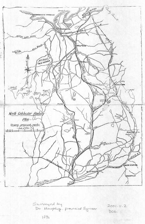
A plan for several railroad routes to connect North Colchester to Truro – 1890 (Colchester Historical Museum Collection)

After confederation in 1867, Canada’s future prosperity and sovereignty were thought to lie in a network of railways between the Atlantic and Pacific coasts with spurs and loops to include growing communities away from the main lines. The Intercolonial Railway connecting Halifax, via Truro, to Central Canada was established in the early 1870’s. It expanded upon local railways between Halifax, Windsor and Truro as well as a railway system in Pictou County linking the industrial towns.

In the mid 1870’s another project was proposed to construct a short line between Pictou and Oxford Junction which connected Scotsburn, Denmark, Tatamagouche, Wallace and Pugwash to the outside world. The project was fraught with financial difficulties but eventually went into operation in 1889.

With the main lines from New Brunswick to Halifax and Cape Breton functioning along with the Short Line from Oxford Junction to Pictou, further regional lines were being explored. It must remembered that this was long before cars and trucks were being imagined to transport people and freight from rural villages to the major towns and beyond.

The idea for a railway through the Cobequid Mountains to the Northumberland Strait was considered as early as 18601. At that point, the proponents suggested, it would afford the shortest route between Halifax and Charlottetown. It was only 129 miles from downtown Halifax to the Brule Corner wharf whereas it was 175 miles between Halifax and the port of Pictou. Brule Harbour was more easily navigated than the narrow river channels approaching Tatamagouche. In winter, the mails and freight could be sledded across the Strait in a straight line to Charlottetown. Tatamagouche had some “goose holes” that didn’t adequately freeze for heavy traffic. By the 1860’s, Brule was already being used to convey passengers and mail to Prince Edward Island with help from a stage coach service out of Truro2.

In the end, the idea was shelved in favour of a link by the Nova Scotia Railroad between Stellarton and Pictou. Pictou was, to be fair, a shire town with a mature port in place and a rail link with nearby New Glasgow would be a bonus to the domestic economy of West Pictou. One would imagine the costly pier style bridge across the upper reaches of Pictou Harbour was an engineering challenge yet so were the 15 or so miles of steep grades through the Cobequid Hills near Earltown. The Pictou link was completed around 1867 and interfaced with a substantial shipping to major ports in the Gulf of St. Lawrence.

In 1890 Provincial Engineer D. Murphy came to North Colchester to survey potential routes from the Short Line through the Cobequid Hills to Bible Hill. area.

Brule Harbour figured prominently in all the routes explored. At that time the wharf at Brule Corner was a busy spot with resident sea captains, foundry, a cannery and was a convenient port for the shipment of timber to the United Kingdom. Brule’s nearest access point to the Short Line was at Denmark, four miles inland. Both Earltown and New Annan were well-established farming and lumbering areas at the time with far larger populations than today. It was likely felt that rail access would further enhance the prosperity and standard of living for these inland communities.3Brule Harbour figured prominently in all the routes explored. At that time the wharf at Brule Corner was a busy spot with resident sea captains, foundry, a cannery and was a convenient port for the shipment of timber to the United Kingdom. Brule’s nearest access point to the Short Line was at Denmark, four miles inland. Both Earltown and New Annan were well-established farming and lumbering areas at the time with far larger populations than today. It was likely felt that rail access would further enhance the prosperity and standard of living for these inland communities.

The most easterly option explored began at Brule Corner crossed the Denmark road and proceeded south to the east of the settlements along that road. It joined up with the Short Line at the Denmark station and then continued due south to Mountain Road and eventually MacBain’s Corner. Crossing the Scotsburn Road, it followed the Nabiscamp Brook through the valley to Rossville, cut behind the Presbyterian Church and struck off above and behind the MacIntosh farm. It emerged again to the east of the Earltown Village cemetery.

Judging from the photographs of the day, it would have followed the Berichan Road down behind the DOT garage and cut along the side hill towards the Kemptown Road. To avoid the grade of Gunn’s Hill, the route appears to go up the Kemptown Road and then follow the ravine to the south of Highway 311 to Sutherland Road. Beyond Sutherland Road it would have followed the MacGill Brook behind the farms on the Summit until it reached the North River. From there it followed the banks and descending grade of the North River and then on to join the ICR near Marshall’s Corner.

A proposed centre route shows a spur starting at Brule Harbour and heading southwest to a point near Ferguson’s Crossing on the Upper River John Road where it would have intersected with the Short Line. From there it would continue through the forest to Balfron and cross what was then the main road near the Simon Cameron Road. It would cross the Waugh River near Balfron Hall. This would likely have warranted a siding as there was an active grist mill, sawmill and tannery at nearby Urquhart’s Bridge. The route would then follow to the west of the present 311 to a point behind St. Andrew’s Kirk at The Falls and later cross the main road to follow the course of the Waugh River through the valley to West Earltown. At the end of the Ferguson Brook Road, it was to tack to due south and follow what is now an electrical line right of way through the pass to Nuttby and would have emerged behind the Baptist Church. From there it follows the same route as the first option. One would suspect that a station or platform siding would have been constructed at Ferguson Brook Road to serve Earltown Village, four miles to the east. One can also imagine a “whistle stop” at The Falls to serve the mill and stores in that community.

The third option is the same between Brule and Balfron Hall after which it turned westward towards Central New Annan. Between the New Truro Road and Central New Annan, it would have made a sweeping turn to navigate the grade and follow a dale through to the crossroads at East New Annan. From there it followed the New (or Old) Truro Road through the hills to MacCallum’s Settlement and on to Marshall’s Corner.

The scheme lay dormant for a few years until the Midway Railway, the operator of the line between WIndsor and Truro, was granted the exclusive franchise to extend their line northward through the Cobequids to the Northumberland Strait. The survey continued to be updated with an extensive review of the 1890 survey in 1901 followed by a meeting in Earltown in November at which time “… a committee was appointed to interview the directors of the M.R. (Midland Railway) of N.S., with a view to securing their aid in promoting a line to be called the North Colchester Ry., and to run between Truro and Brule. It was also decided that the committee should draft a bill for the next session of the Provincial Legislature and the Dominion Parliament next year.”4

The Provincial Government of the day was very anxious to see this happen and it would appear that they were more enthused than the residents of Earltown. Whether it was a matter of political opposition, fear of expropriation or general apathy, there is no narrative of these events either orally or in Sutherland’s “Rise and Decline of the Community of Earltown”.5

A view from Ross’s Rock on the west flank of Spiddle Hill overlooking the Waugh River valley at West Earltown. This photo is from the collection of Edmund Haskett-Smith, an surveyor from Britain who came to Tatamagouche and worked on some of these surveys. He employed a photographer by the name of Adams from Truro. In the days before satellite images and topographical maps, the photos were likely used to illustrate the lay of the land to company officials and government bureaucrats. Haskett-Smith collection courtesy of John Crawford

The February 1903 issue of The Railway and Shipping World trade magazine reports that “Surveys have been completed for a railway from Truro, N.S., where a connection would be made with the Midland Ry. to Tatamagouche across the Cobequid Mountains, about 35 miles.” The reporter goes on to explain “Some years ago surveys were made for a line from Truro to Brule over much the same country and it is understood that the first 18 miles of this old survey, (from Truro), will be followed. This would carry the line to Earltown, from which point P.S. Archibald, CE, recently made a survey via the Waugh’s River, a little to the west of the survey to Brule, and crossing the Oxford branch of the ICR about a mile above the railway bridge at Tatamagouche.”6

In June of 1903, it was announced that the Waugh River route had been chosen subject to minor modifications. The junction with the ICR Short Line would be about a mile east of Tatamagouche Station and a spur would run north to the narrows of Barrachois Harbour7.

It would seem Brule had lost some of its strategic importance by that point whether through a reduction in harbour traffic or it just made sense to connect up with the Tatamagouche Station. This route seems to be the chosen one but not the shortest. By looping east, much like the current 311 highway, there was more exposure to the populated areas of the Waugh River valley than across the mountain to East New Annan.

Here is a (link) to a map showing the four routes contemplated. Without precise historical maps of the routes, this is my attempt to plot the potential routes while respecting the topography of the area.

The project was likely the subject of much excitement at the time and probably generated some healthy skepticism. Like the Short Line before it, capital for such a difficult terrain was not forthcoming anytime soon. These connector lines were heavily dependent on Provincial and Federal subsidies. A few years later, the writing was on the wall that internal combustion engines would adequately serve those inland communities. The writing was also on the wall that the farms of Earltown and East New Annan were vacating at rapid pace. However it is fun to imagine what things would be like today had the project gone forward.

  1. The Railway and Shipping World April 1902 as reproduced in the Dominion Atlantic Railway Digital Preservation Initiative (DARDPI) ↩︎
  2. Fun fact: In 1864 delegates from Nova Scotia travelled to Charlottetown to attend the conference that would begin the process of creating Canada. The delegates traveled from Halifax to Brule Corner by stage coach from Truro through Earltown to Brule Corner where they boarded a vessel for Charlottetown. Per “A History of Brule and Brule Point” ↩︎
  3. Beeler, Donald A History of Brule and Brule Point, 2008 ↩︎
  4. The Railway and Shipping World November 1901 as reproduced in the DARDPI ↩︎
  5. One wonders about the politics. This was a pet project of Liberal Premier George Murray. Murray, while a descendant of the Sutherlandshire diaspora, probably didn’t have a lot of support in Earltown where there was a predominant conservative affiliation from the times of the colonial elections. We will talk about politics in a later post. ↩︎
  6. The Railway and Shipping World February 1903 as reproduced in the DARDPI ↩︎
  7. The Railway and Shipping World June 1903 as reproduced in the DARDPI ↩︎

Part II Marion MacLeod and husband “Billy Ban”and Donald MacLeod

William “Ban” Sutherland, commonly known as Billy Ban, was also a native of Clyne and a son of John Sutherland and Margaret MacKay.  Ban or Bahn is Gaelic for blond or fair-haired.   This descriptor was essential as there were three first settlers within a mile named William Sutherland: William “Ban”, William “Caribou” and William “Ruidh” or red.   By 1868 there were three Williams living in a row: William Ban, William Caribou and William Sawyer all of whom were visible from the stoop of William Ruidh across the river.  Add to this Rev. William at West Earltown ,  Willie Cairn and Billy Buidh in Balmoral, followed a few years later by Gib’s Willie across the river.   As an elderly interviewee quipped several years ago, Will Sutherlands were standard equipment in those days.

In addition to carving out a farm on the side hill, he conducted classes before a formal school came to the district.

The descendants of this couple will be fully featured in a future post but for now we will notice that they had eight children:  Christy Sutherland in Idaho,  Jane MacKinnon in Malagash,  Lillian MacDonald “MacAdam” at East New Annan and later California, Hughena MacDonald in Bayhead, three children who died young plus John “Ban” who inherited the homestead and, with Mary Henderson, produced thirteen children.

Donald MacLeod

As mentioned previously,  Donald MacLeod acquired the western 100 acres of the Moore grant which was located on the west side of the river.  The farm was almost entirely cleared to support the large family therefore woodlots were acquired further afield.

 He married Barbara Gunn in the mid 1830’s.  Barbara was born in Strath Halladale in the far north of Sutherlandshire.  Her parents,  William Gunn and Dorothy MacKay, emigrated around 1830 to Pictou County and a few years later acquired an uncleared farm immediately to the south of Hugh MacLeod’s grant at West Earltown. 

This couple had ten children:

  1. Marion  (1838-1865) was married to James Nelson of Balfron. Her marriage was tragically cut short by her untimely death a couple of months after the birth of their twin sons.  Donald and Barbara partially raised the two boys.
  2. Hugh – died in infancy
  3. Dorothy or Dolina (1840-1924) married George Sutherland “Ruidh” across the river.  They had a family of eleven
  4. William MacLeod 1843- 1908 to be noticed later
  5. Catherine MacLeod 1845-1917  married John Urquhart, Merchant, at Urquhart’s Bridge in Balfron
  6. Hughena  1847-1916  married William Gaillie Fraser of Durham and lived in Truro where William, or “WG” as he was known, was an accountant.
  7. John died at the age of 2
  8. Donald, known as Dan, 1857-1922, to be noticed later
  9. John, 1858-1933,   heir to the main homestead
  10. Alexander  1864-1906  married Charlotte MacCulloch.  Alex was employed by the railway out of Truro and was killed in a train accident in Bible Hill leaving a widow and young son, Daniel.

William MacLeod, oldest surviving son of Donald, was given the southmost 50 acres of the farm.  The homestead still exists as the Ferguson-Lemoine property.    William married Georgina Sutherland “Square”, daughter of   Gilbert Sutherland “Square” and Marion Campbell. Her childhood home was located near the junction of the Gil Sutherland and Spiddle Hill North roads.

This couple had nine children:

  1. Dolina  1867-1909  who married John Sutherland “MacIan” of West Earltown.  They lived at Balfron near Urquhart’s Bridge.  After her death John married Marion Urquhart and moved to Vancouver.
  2. Marion 1868-1950   was known as Minnie.   She married Alex Murray “Corrigan” of Spiddle Hill.  When their family was young, they moved off Spiddle Hill to the old Murray bonesetter farm down by the river near Murray Cemetery.   They had a family of eight children: Donald Murray of Pictou, George William who died in his early twenties, Anna (Mrs. Archie Cameron), Gilbert (Beatrice MacLeod) on the home place, John R. in Massachusetts, Aubrey in Ontario, Jean (Mrs. Gordon Baillie) and Christene (Mrs. Archie MacDonald).
  3. Barbara (1872-1952) married Donald S. MacKay “Uhr” of Kavanagh’s Mills.  They lived in Watertown, Massachusetts, where Donald was manager of an elevator company. They had four children.
  4. Jane 1873-    married Robert MacKay, Tailor, of Earltown. They lived in Marshville and had a family of three.
  5. Dorothy died in infancy
  6. Alexander  1879-1939
  7. Catherine 1880-1960 married Dan Baillie of  Spiddle Hill.  They lived at The Falls where Dan operated a sawmill.   They had two children, Jean and MacLeod.
  8. Christena 1883-1973  married George MacKay “Achany” of The Falls. They operated the general store at The Falls before moving to Tatamagouche where they also ran a well known store.  Until recent years it operated as MacKay Brothers.   They had five children.
  9. George 1886-1966    who was well known as Geordie MacLeod.  He continued to farm the home place until his retirement. He married Anna Ferguson of West Earltown.  They had five children,   William in Ontario,  Donald in Ontario and later the homeplace at The Falls, Avis (Mrs. Lloyd Dickie in Middle Stewiacke), Georgine (Mrs. Ross MacKay, Balfron) and Roy in Ontario.

Dan MacLeod, son of Donald, married Margaret Baillie of West Earltown.  Their first home was near Wallace but they returned to The Falls when the Sutherland farm to the west and above that of his father became available.  Dan was an elder of St. Andrew’s Church.  His obituary sums up his character: “The late Mr. MacLeod was very kind hearted and hospitable and his home was always open to the way-farer, and the stranger was often entertained there.  He never turned any one away hungry from his door.”

Dan and Maggie had three children:

  1. Daniel   1883-1953 was unmarried and lived with his unmarried uncle and aunts,  Alex, Georgie and Bessie Baillie, at Kavanagh’s Mills.
  2. William John (Willie John) 1886-1959
  3. Barbara  1886-1932  who lived in Brookline, Ma., where she was a domestic. 

Willie John lived his entire life on the family farm.  He married Sadie Hayman of Balmoral and had  Harold of Tatamagouche,  Christene Morrow, Helen Loughead and Kathleen Geddes all of Truro.

John MacLeod, son of Donald,  retained the original homestead of 50 acres.  He married Elizabeth “Betsy” MacKay, daughter of  John MacKay “Black” and Janet MacDonald “Salt” of Balfron.  The writer’s father and aunt often spoke of when they were youngsters visiting  John and Betsy  at their home.  They were very fond of children and went to great lengths to entertain their young guests.   Their family:

  1. Barbara   1882-1971  married W.R. “Rod” Murray of Rossville
  2. John          1885-1891
  3. Dan Robert 1888-1970 married Mabel Murray “Og” of West Earltown.  They lived in Trail, British Columbia
  4. Jessie        1889-1987  married Alex Gunn of Brule
  5. John Will  1891-1971  never married
  6. Marion       1895-1918
  7. Catherine 1898-1967   married Gordon Murray “Og” of West Earltown.  They lived for a few years on his father’s property on Cnoc Na Guidhe before moving to Upper River John Road.
  8. Alexander  1902-1989   never married and lived in Trail, British Columbia

John Will was a unique and kindly character in the writer’s youth.  He retained many of the old ways, particularly in speech, and had his own sense of humour.   He was often on the receiving end of pranks played by his first cousin  Geordie who lived across the field.   John Will drove an old Model A Ford into the late 60’s.   The old car was driven slowly.  Whenever one of the students at our school at Balfron noticed the car approaching from The Falls, the teacher was alerted and we would be dismissed to go outside to watch John Will creep by and toot the horn.   On one occasion a young businessman originally from the area went to see John Will about buying the Model A.   In hindsight it was probably unwise of the young fellow to arrive at the MacLeod homestead driving a bright red Corvette.  When asked whether he would consider selling the Model A,  John Will glanced out the window at the Corvette and replied,   “I think the car you already have out there is plenty good enough”.

Hugh MacLeod – Patriarch of The Falls

On June 25th, 1821 Hugh MacLeod and his four children caught their last glimpse of their native hills of Eastern Sutherland from the deck of the Ossian bound for Pictou in far off Nova Scotia.  Until May 30th of that year, the family had lived for generations in the declivity they could see on the horizon, the river valley known as Strathbrora. 

They were not alone on this adventure. They were one of twenty-one households all from the same parish of Clyne in Sutherlandshire and some would become their neighbours in the new land.

On the morning of May 30th of that year, and not without warning, an eviction crew under the direction of the Sutherland Estate began the removal of the final inhabitants of the Strathbrora.  There had been previous evictions in Clyne and several folks left voluntarily the previous year for either Caithness to the north or the colonies in North America.  Most of those families had the financial means to acquire farms elsewhere or pay passage across the ocean.  The last remaining group first delayed the action by claiming an exemption brokered by their minister[1] when eviction became a possibility.   Although small lots had been offered near Brora, the remaining inhabitants waived the offer and were prepared to mount a resistance. [2]

While the actual work of eviction was carried out by some thuggish characters in the employ of the estate, a small regiment was dispatched to the area as a violent resistance was expected. In most cases, the families gathered their belongings and left while the more militant fled through the back country to Caithness.  As was the pattern, the homes and crops left behind were burned to discourage people from returning.

Assurances from their minister aside, the evictees of 1821 were mostly of limited means otherwise they would have emigrated to Pictou during the previous two years.  By 1821, a son of their former laird, Joseph Gordon, an Edinburgh lawyer, had raised funds to subsidize passage to Nova Scotia.  The funds were primarily raised by his brother George Gordon, a merchant in Bombay, India. 

Between May 31st and June 25th, Hugh MacLeod and his family made the journey south to Cromarty in Easter Ross.   No legends were handed down as to how they lived during this three week time period but other accounts would suggest they lived in the open or sought shelter in byres of people along the way.  

The manifest of the Ossian’s voyage lists Hugh MacLeod, age 50,  as head of a party of six adults which would most likely include his wife, Mairead Sutherland, and four known children:  Marion, Margaret, Donald and John.  The fare was four Guinies and half for each adult which equates to $102 Canadian dollars in 2024. [3] 

The departure of an emigrant vessel from the port would draw spectators both acquainted and just curious.   As the sails snatched a breeze and proceeded to glide from the bay, many on shore would be greatly affected and brought to tears.

Pre emigration

The MacLeods, as a clan, were primarily based in the Northwest Highlands and Islands.  It is not known how they came to be in Clyne in the 18th century or if they even had ties to the main clan.  Hugh and Mairead (Margaret) first appear in the Old Parish Register in 1799 presenting their daughter Marion for baptism.   They are listed as living at Kilbraur.   This residence was also listed for the baptism of Margaret and Donald.   By the time John came along, the residence was noted as Dalvait and Hugh is noted as being a tailor.

Hugh is not listed on the various rent rolls as a direct tenant of the Estate. Most likely he was a subtenant.  Pre-clearance Strathbrora was arranged in a manner that tenants or sub-tenants would have a strip of arable land along the river and grazing privileges in the back country.  For a subtenant, this would not be a substantial farm hence the need for Hugh to ply another vocation as he did tailoring.

Hugh’s likely marriage around 1798 at age 31 would suggest that he likely served in the military like many of his neighbours and fellow emigrants.  

Arrival in Pictou – Now what?

It is not known how long it took the Ossian to cross the ocean to Pictou but the time would be measured in weeks.  Whatever the exact date, summer was well along and there would be no crop that year.   The scene that greeted the passengers would be much different than their countryfolk would have seen back in 1773 or even in 1803.   Pictou was now a well-established town accustomed to a stream of emigrants landing on the wharves and looking for directions to a possible new home.

Hugh Denoon, a former emigration agent in the Highlands, was now employed as the land agent in Pictou doling out acreages of unsettled land along the Northumberland watershed.  The land agent would assist with preparing a petition to the colonial government for a grant of land.   In the meantime, he would direct migrants to the main settlements receiving settlers.  By 1821 this could be the upper settlements of Barney’s River, the upper settlements of the Middle and West Rivers of Pictou or the headwaters of rivers ending at River John and Tatamagouche.

A contingent of Clyne immigrants arrived in Pictou in 1820 with a noticeable proportion taking up land in the Earltown area including The Falls.  Consequently, it made sense for the MacLeods to head in that direction where there would be some familiar faces with experience in pioneering.  Hugh was a given a ticket of location on the Tatamagouche River.[4]  A petition dated February 5th, 2022 describes Hugh MacLeod, about 50 years of age, wife and 4 children emigrated from Scotland in 1821.  MacLeod asks for land at Earltown. He was approved for 200 acres.[5]  This eventual grant was located on what is now known on the Spiddle Hill South Road approximately a half mile north of Highway 311 at  West Earltown  The grant straddled the river, included some potential meadowland on the east side of the river and extended up the slope of Spiddle Hill.

Across the river on the hill, three generations of the “Black” Robert MacKay family put down roots.  They were fellow passengers on the Ossian and hailed from Aschoilbeg near Dalvait.  To the east was land granted to Robert and John Baillie of Clyne who chose not to settle in Earltown and likely settled in Pictou County.

While most settlers were very content with the land they were granted, ownership being something neither they nor their ancestors had ever experienced, Hugh later petitioned the government to exchange his grant for another location.   The land, he explained, was wet in places and was situated in a valley that was very susceptible to early frosts.   His request was denied and the family remained at West Earltown for the time being.   In 1830 John and Susannah Moore[6] started selling off their substantial reserved land grant at The Falls.  In that year individual deeds were granted to each of Donald MacLeod and John MacLeod.   Donald, his wife and one child were settled on their land at the time of the 1838 census but John was still living on the original farm at West Earltown with his bride, infant son, mother and sister.

The John MacLeod homestead with Donald MacLeod’s homestead on the hill across the river. Note an earlier dwelling in the foreground between the current house and the barn.


The elder son Donald settled on the west side of the river and a homestead was established on MacLeod Road where it exists almost 200 years later.  Many will identify this as the John Will MacLeod property.   The younger son, John, acquired 150 acres on the east side of the river.  The homestead was on site of the current house and barn which is still owned by descendants.

Homestead of Donald MacLeod as seen today from the local community hall. It looks much the same today as it did 100 years ago.

Immediately to the south of Donald lies the homestead of Hugh’s eldest daughter Marion and her husband William Sutherland “Ban”.   The barn still exists on the shoulder of Highway 311 at the junction with the Gil Sutherland Road. This lot was also acquired from the Moore family in 1830.

Hugh died on April 13, 1830 at his home at West Earltown.   He transformed his family from being lotters or sub-tenants to collective owners of a picturesque 350 acre chunk of The Falls. It is interesting to note that the neighbours on either side of this lot were former residents of Kilbraur, Hugh and Mairead’s original home. William Sutherland “Ruaidh” lived to the north and Gilbert Sutherland “Square” to the south.

   Over the following four generations, the tentacles of this family wove its way through the majority of the local inhabitants of The Falls. Almost nothing is known about Mairead Sutherland.  She would appear to be living in 1838 and the head count of Donald’s family in the 1861 census would indicate she was still on this earth at that point.   Hugh’s stone in Murray Cemetery makes no mention of his wife.   It is worth noting that Hugh is the first recorded adult burial at that location.

[1] The minister was Rev. Walter Ross.  Ross was not well liked by the common folk having been appointed by the Countess, as was the case in those days, and was more attentive of his four legged flock than the two legged variety.  He was often absent from duty which led to the catechists being the true spiritual leaders in the community.

[2] Hunter, J. (2015). Set Adrift Upon the World. Casemate Publishers; and direct correspondence with Dr. Hunter is the primary source for the events surrounding the evictions from Strathbrora

[3] Campey, L. H. (2002). Fast Sailing and Copper-Bottomed. Dundurn. Appendix B

[4] Tatamagouche River was the description in early documents in The Falls and West Earltown.  The name did not survive and the river is Waugh River and named after an early settler of Tatamagouche.

[5] Whiston, Norris  (2009) Northern Colchester Land Grants

[6] Susannah was the daughter of Dr. John Harris, Truro, one time shareholder in the old Philadelphia Company that owned most of West Pictou and the hilly sections of North Colchester.   Their prior stature enabled the descendants of Dr. Harris to acquire some strategic land grants throughout the regions.   John Moore was a miller and had grants on steams suitable for constructing mills.  The Moore’s settled near the junction of the West and East branches of River John.

I